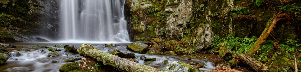
Cascading Waterfalls…And Awesome Hikes
The area that would eventually become Shenandoah National Park has a presidential past. It once served as the summer refuge of Herbert Hoover. The higher elevations and welcome breezes of Virginia’s Blue Ridge Mountains offered the former U.S. President an escape from Washington D.C.’s stifling summer heat. Today, visitors from large cities and small town across the country, travel to Luray-Page County, in the Shenandoah Valley, every summer to take advantage of the Park’s refreshing breezes, cooler temperatures and breathtaking mountain, pastoral, and wooded views.
Shenandoah National Park has its share of breathtaking waterfalls, from gently tumbling cascades, to energetic cataracts that fill the forest with the sound of rushing water, all with hikes, varying in length and difficulty, from which to view them. Deep forest trails are often 10 degrees cooler than lower lying towns, and the same dramatic elevation changes that make iconic Shenandoah hikes like Old Rag and Hawksbills so splendid, also create a plethora of waterfalls and swimming holes to explore.
I have included some well-known waterfall hikes, as well as some lesser known, all in ascending numerical mile marker order, but there are more to satisfy hikers at every skill level. While you’re hiking, keep your eyes out for the wildflowers that abound in Page County. These beauties provide a breathtaking varied display throughout the growing season. The colorful display begins in late March and continues into late fall.
Difficulty rating: Moderately strenuous
Distance 5.1 miles
Waterfall height: 93 feet
Hiking trail mile marker 21.1
Pet friendly
This is the tallest waterfall in SNP, and one of the largest continuous waterfalls in Virginia, with an impressive drop and impressive view. The trail goes through picturesque valley streams and meadows, with rock ledges to sit on and enjoy the view, making this one of the prettiest hikes in SNP. This is one hike where you are most likely to catch a glimpse of Black Bears in the wild.
Difficulty rating: Difficult
Distance: 9.5 miles
Waterfall height: 90 feet
Hiking trail marker: 42.6
Pet friendly
This is the most popular destination in SNP, mostly because it has six waterfalls. Each waterfall, ranging in height from 35 to 86 feet, has a swimming hole at the bottom. These are popular destinations, so you can expect a bit of a crowd. But this incredible atmosphere will well be worth it.
Difficulty rating: Moderate
Distance: 2.6 miles
Waterfall height: 67 feet
Hiking trail marker: 49.4
Pet friendly
This is a cascading waterfall that can have as many as 4 cascades after heavy rain. There are a number of streams and pools for splashing and cooling off. Two back-to-back segments form the whole of Rose River Falls. The top is a gentle cascade into a shallow pool with a nice view downstream. The second is more dramatic, with a waist-deep swimming hole buffered on three sides by steep rock walls.
Difficulty rating: Moderate
Distance: 1.4 miles
Waterfall height: 70 feet
Hiking trail marker: 50.7
Not pet friendly
In Appalachian slang, a “hollow” is a small, sheltered valley. The broad, multifaceted cascades on this hike are entrenched deep within the walls of a steep valley. The series of waterfalls and cascades have some steep sections which can make the hike challenging but standing at the base of this 70-foot falls is worth the effort. A shallow pool at the base is a welcome stop on a warm summer day.
Difficulty rating: Moderate
Distance: 3.3 mile
Waterfall height: 81 feet
Hiking trail marker: 51.4
Pet friendly
Unlike the rest of the hikes on this list, the only view of Lewis Falls is from up high, but what a view! The roundtrip trek leads to a rock-walled observation platform. The falls erupt out of dense tree cover before falling, uninterrupted for 81 feet to the forest floor below. The breathtaking vista extends for miles, but perhaps the best perk of this hike is the sheltered cove to the left of the large waterfall sign, just before you reach the observation spur trail. It’s a shady picnic spot, like no other. The hike includes a rocky downward slope, with some very steep areas that make for a challenging decent.
Difficulty rating: Moderate
Distance 3.3 miles
Waterfall height: 83 feet
Hiking trail marker: 62.8
Pet friendly
This is the 3rd tallest waterfall in SNP. One of the most spectacular experiences in Shenandoah National Park is standing in the thigh-high pool at the base of South River Falls, gazing at its precipice 83 feet above, and being sprayed with its cooling mist. It takes some effort to achieve this experience, but it’s worth every step. Hikers also have the opportunity to watch from an overlook above the falls, as the water thunders down to the stream below.
Keep safety in mind when hiking, always use common sense, and stay on the trail. Stay away from the edges, especially when hiking waterfall trails, where more than likely rocks will be wet and slippery. Always bring drinking water, dress in layers and wear sturdy hiking boots. Keep in mind that your cell phone and GPS may not work while out in nature, so plan ahead by mapping out your trails. Make sure to stop by The Luray-Page County Chamber of Commerce & Visitor Center in the Town of Luray or Harry F. Byrd Visitor Center and Dickey Ridge Visitor Center in SNP to pick up maps of the trails you are interested in hiking. Check the Parks hiking alerts and conditions page for updates on trail closures and safety notices. Keep in mind, trail markers are concrete posts at trailheads and intersections with metal bands stamped with directional and mileage information. Trail blazes are painted stripes on trees and rocks throughout the park. Blue blazes signify hiking trails, white signify the Appalachian Trail and yellow signify horse trails.
While you’re in the park, driving Skyline Drive, the scenic byway that traverses the length of Shenandoah National Park, a “must do,” is a drive to one of its most famous features, the Mary’s Rock Tunnel. Constructed in 1932, by blasting through the mountain, it is considered an engineering marvel. The tunnel stands nearly 13 feet high and extends 610 feet long, and sits at mile marker 32.2, slightly south of the Thorton Gap Entrance to Shenandoah National Park. Mary’s Rock Tunnel provides a little adventure for visitors traveling the scenic byway. Folks needing to stretch their legs can pull off at one of the 75 breathtaking overlooks along the route and get out and experience the views of Shenandoah National Park. The park showcases rolling mountains and provides a home to wildlife suck as deer, black beer and wild turkey. Don’t forget a camera. Although photos do not do the views justice, you’ll want to capture the surrounding beauty of the Shenandoah Valley!